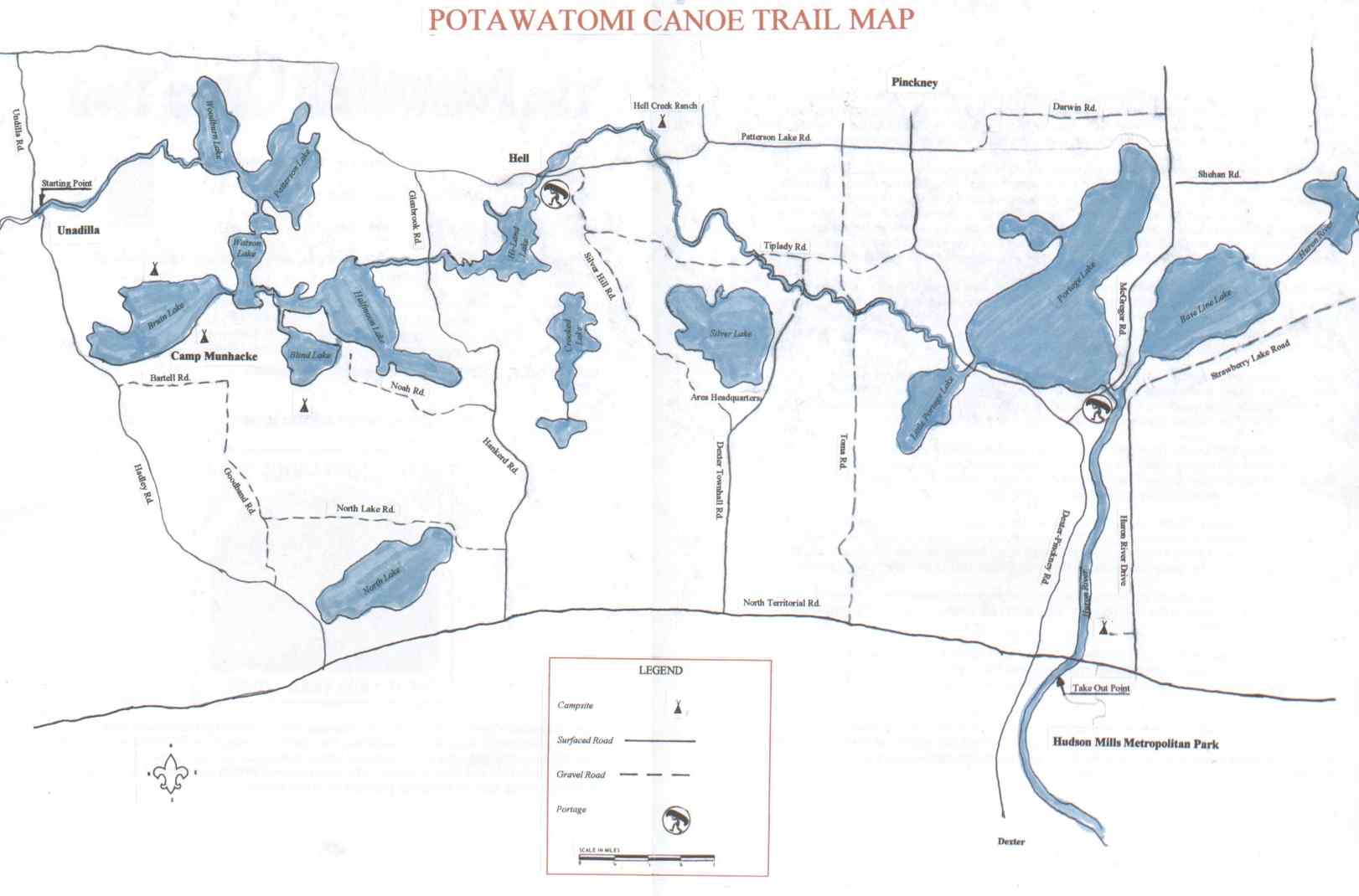
 The Potawatomi Canoe Trail is a 20-mile waterway that winds through the private land, Pinckney Recreation area and Huron-Clinton Park land in Livingston and Washtenaw counties. This trail is a small segment of the historical Indian canoe route across southem Michigan between Lake Erie and Lake Michigan. The blend of small stream and chain of lakes makes for a unique setting, and will challenge paddlers of all skill levels. Map - 81,000 bytes JPEG Full Text Description: The up stream starting point is at Unadilla and finishes at Hudson Mills Metro Park. Obtain permission to launch canoes and diplomatically select a last minute purchase from the Unadilla General Store... The Unadilla General Store has been serving the area for many years. The two portages at Hell and Portage Lake are over dams used as water level control and can be handled easily for intermediate canoers. After a small quiet stream from Unadilla, the water opens to the Half Moon Lake chain, starting with Woodbum Lake, traveling through Patterson and Watson Lakes, and under the little Mackinaw Bridge, which spans the channel connecting the Potawatomi trail. A side trip to the clear green water of Blind Lake is a highlight for any canoe trip. The old Glennbrook campground, just ¼ mile down stream fmm Halfmoon Lake, makes a good rest stop with pleasant surroundings. White tail deer, duck, muskrat, mute swan and other wild life frequent the quiet and tranquil stream from Halfmoon Lake to Hiland Lake. When entering Hiland Lake from the channel, stay to the left of the island. Just past Hiland Lake is Hell, which is the first portage. The dam at Hell is used as a water level control and the portage can be done easily by staying to the left. Hell offers picnic tables, a party store, restaurant bar, and souvenir shop for your convenience. Below Hell is Hell Creek Ranch. The Hell Creek Ranch offers camping and has a good access for take out for those paddlers who want to stop. The stream slowly meanders through hardwood forests and low lands. From this point to Portage Lake the stream becomes remote and more challenging. The tight turns, leaning trees, brush, and occasional obstruction may be tricky and difficult for beginners. A few fallen trees that require lifting your canoe over may also be encountered, but they appear to be cleared annually. One or two chutes create light rapids to the delight of most canoeists. Between Tiplady and Dexter Town Hall Road a faster current makes this section challenging. The extremely sharp and narrow bends will test maneuvering skills of even experienced paddlers. Shooting the rapids under Dexter Town Hall Road, just past a private drive, makes for exciting canoeing. The private bridge may need portaging during high water. The canoe trail between Dexter Town Hall Road and Toma Road bridge has a high bank and more carry overs. A portage is required just past Toma Road crossing This is a private residence driveway so respect is always the rule. Stay to the left when leaving Portage Creek and entering Little Portage Lake. After going under Dexter Pinckney Bridge stay to the right in Big Portage Lake. There is a public access site on Big Portage Lake by the channel to Huron River. The control dam just past the public access is the next portage. Stay to the left where you will find a wood ladder system for easy portage. This section is the Huron River, and final leg to Hudson Mills Metro Park. The river is 60 to 90 feet wide with mostly slow water except for the shallow ripples below Bell Road. With its clear water, rock and gravel bottom, and attractive unspoiled surroundings, this designated scenic natural river is a favorite with canoeists. Hudson Mills Metro Park has been the site of a sawmill, gristmill, cider mill and plaster mill, the earliest dating back to 1827. Today only the ruins remain. There are rapids just past Territorial Road Bridge, that create standing waves. If in doubt, portage on the left just beyond the bridge. The take out point is on the left at the end of the rapids. |